skip to main |
skip to sidebar
Thursday 8th October 2009: Day 3
Little Salkeld to Gateshead - 70 miles approx
203 miles running total
"Well, after a reasonable night's kip, it was an early breakfast and out onto the road by 10am, which was quite impressive for us. All rather hilly to start with and then after only 2 miles, we find our way blocked by a dug up road and a spot of roadworks.
So we headed towards Gamblesby before rejoining the original road near Renwick. Knew I bought those Sustrans maps for a reason.
And then the climbing started.
 We were up at about 1000ft at this point, and Mr McDonald was suffering.
 Suffering with a smile though.
 Luckily, the weather was decent, you could see for miles. And speaking of which, you can see the cafe on the top of Hartside over on the left of this picture, miles away. I'm not sure that helped really. It looked a long way, all of it uphill.
 So while I breezed up the hills effortlessly*, Ian took a bit longer, though it did mean a few lovely photos of him trundling up another steep bit. And this was a steep bit.
* Ok, so perhaps there was a little effort involved.On and on up towards Hartside summit, on a very twisty road, but it was a lot easier than the off-road option. And then a spot of rather uninspiring nosh in the cafe just after midday. The view was great though. Probably should have taken a picture. We did remember to pose by the sign as is customary, though Mr McDonald wanted to get going. Look, here he is the happy little camper. I think he needed the toilet again.
 And he's our dashing hero, looking dashing. It was bloody cold up there. Bit of a breeze you know.So, despite the cold, there was a very nice downhill section to enjoy afterwards, Ian went racing off at about 90mph as usual, too fast for pictures, but we reached Garrigill in about 45 minutes.
 This is the road out of Garrigill. Well, less of a road and more the side of a cliff. Look at my feet to get some idea of the angle. You could hardly stand. The next 250 yards were the steepest bit so far by a long way. We both got about about 75 yards, though of course I stopped so as not to embarrass Ian. We walked for a bit. Slowly.
 Half an hour later, and we're ploughing on up another long stretch of hill. Flinty Fell it's called, though we were calling it something else. You can just make out Hartside Cafe on the horizon if you zoom in above his head.
 Full of energy and raring to go. (Well, I had been waiting for him to catch up for about 10 minutes)So, after what seemed like forever, we made it to the top, and after a quick break, it was off down the steep hill into Nenthead.Ian as usual went tearing off at about 40mph, "see you at the bottom" and all that, and he was long out of sight when for some unknown reason, and with a very loud bang, my front tyre's inner tube burst.Must have been doing about 25mph at the time, and things went very wobbly for a few yards, but luckily the tyre stayed on the rim and I managed to stop in the vertical position.Not the easiest place to fix a puncture due to the severe incline, so I had to wheel the bike down the hill which wasn't half tough on the legs, so it took about 10 minutes to get down into the vilage. At which point I saw Ian, clearly in a hurry to see why I was taking so long. Or not.Well, we changed the shredded inner tube with a new one, Ian went for a dump again, and we retired to the village shop for a cup of coffee and some food.
  Puncture fixed. Still alive.
 You can see the hill where the tyre had gone, just up on the horizon there by the telegraph poles.
Once the nerves had settled and the hands weren't shaking quite as much, it was getting on for 4pm, which meant the daylight wasn't going to last all the way home. In fact we'd probably only done about a third of the required miles for the day. Time to get moving.
Another very steep hill out of Nenthead on the road, and we made it with a certain degree of jubilation to the highest point on the route, at 2000ft
 It's all downhill from here Ian**lies
 Quite a view from up there. And into Northumberland too. That's like the next county along from home really, isn't it?
 A nice view.
 Not such a nice view. Can't tell if that's a grimace or a smile.
 Now, that's a smile. Probably a Sound Of Music moment or something.
So on we pressed, grateful that we hadn't opted to spend the previous night at Allenheads like we'd originally planned. I mean, we still hadn't reached it and we'd been cycling for 6 hours that day already.
Can't say I was too keen on going fast on the downhill sections after the blowout at Nenthead, but Ian will tell you I don't go fast downhill anyway.
Allenheads was reached just before 5pm, toilet stops of course, and then after the steep climb out of the village we stopped at Currick summit around 5.20pm for a last photo before the daylight went.
 I don't like the way he's winking in the background.
 It's the border of County Durham you know... Well, after that, there was a nice downhill stretch past the old mine workings, where Ian managed to fall off when he stopped and forgot to release his foot pedals. I missed that, which was a touch disappointing.
We got into Rookhope and decided to take the "easier" route along the road to Stanhope and then up to the Waskerly Way. Apart from adding about 4 miles to the route, it also added Crawleyside Bank as well. Bad idea.
We pushed it most of the way up, and it was totally dark by the time we reached the top. We'd not eaten enough really, and I don't have the reserves to dig into like Ian, so I was exhausted by the time we reached Parkhead Station around 7.15pm.I've always liked the place, but it was especially wonderful this time.
The best toasties ever made were eaten, along with some carrot cake too, and together with a hot drink and a rest, we were ready to set off again about 8pm.
It was pitch dark on the moors, and bitingly cold too, with the thermometer on the bike computer showing 0°C, but we kept going. Ian had a much brighter light, so he was racing away like he does on the downhill bits, so I had to keep reigning him in as I couldn't see that far.
He grumbled a bit at my slow speed, but we made it down the old railway line to Birtley at 10.35pm without killing each other. By this time, we were both pretty numb with the cold, as we'd been freewheeling most of the previous 2 hours.
Well, the last bit from Birtley saw us get a bit of a second wind. Probably just to warm up. Don't think we've ever done it so quickly. Those toasties are clearly performance-enhancing.
The Black Horse was reached, and at 10.59pm, I banged on the window and scared a few of the locals. We'd done it! See. We even got back in time to get served.
 Here, I show Ian how many days he should take to cycle the route next time.Stats for the 3 Day trip:
Total Mileage: 203.6 miles
Total Time Cycling: 21hrs 04mins 30secs
Dunk's Max Speed was 32.8mph - Ian's was considerably faster, but he's mad.
Average Speed of 9.6mphAnd that's it. I think we'll have to do another one in 2010.
I'll leave you with this hideous image found on the camera. Could have been a lot worse I suppose.
I'll post the Google Earth file sometime before the end of the year with the last day's route on.
Wednesday 7th October 2009: Day 2
Gretna to Little Salkeld - 55 miles approx
133 miles running totalA cold and frosty morning greeted us when we managed to get out of the very comfy beds at Surrone House and downstairs for a nice cooked breakfast. I suspect the cold weather and the fact we only had about 55 miles to do today, mainly on the flat, meant we were a little later getting away than was ideal. About 10.30pm actually. But at least no waterproofs were needed.
Cycling along with Ian, you learn that he's not one for stopping, so apologies for the lack of photos at this early stage of the day (or in fact later on as well... ahem)
We pressed on and reached Longtown in about an hour, which of course meant finding the public toilets for Mr McDonald. I'd have taken a picture to set the scene, but well, you know, I suspect there are laws and all that.
We stopped at the Gretna Bakery on the main street and got some nice Steak and Onion pies for later and then set off again.
First snag of the day as we missed a route 7 sign a few miles up the road and only twigged when we got to the busy A7, so we turned back and managed to get on the obscured cycle path. We did an extra mile by accident. Curses.
 Blimey. Look. A picture!Only about 2 hours into the day's cycling and on a stretch of old railway line near Westlington, we remembered to get out the camera. It's got to be packed away when cycling 'cos it's too big to go in a pocket and pedal comfortably. The next trip needs a slimmer camera.Just past this point we found a rather confusing route 7 signpost and ended up deviating from our original planned route. Sustrans need to do a bit of work here. In fact, they need to do a lot of work.So instead of heading south towards Carlisle, we were heading west towards the M6 for a while, though after crossing it, we did turn south and followed some incredibly straight roads past the Kingmoor railway yards. Not wildly exciting this stretch to be honest. The route 7 signs were ancient, so it was probably the original route.And then we trundled through the suburbs of Carlisle, through a park, across a bridge, along a footpath / cyclepath or two and then the route 7 signs ran out and route 72 ones started. Arsebiscuits.Ian's fancy SatNav meant we knew roughly where to go, but not quite how to get there because it wasn't fancy enough.Anyway, for future reference, if you're on Bridge Street heading west, turn left onto Viaduct Estate Road, which is where we went wrong due to missing signs.
Of course, when we found Route 7 again, sod's law ensured it was closed and being dug up, so we had to find our own way across the river. Should have turned right over Nelson Bridge, but we went straight on and got very lost for ages before we found the riverside route again. We lost an hour in total which wasn't great. Looking back I should have had loads of photos of us looking flustered and lost. Oh well.It was time for lunch. You can click on this majestic panorama to get the full impact of Mr McDonald's fine physique.Nice spot to eat though. Them pies from Longtown were excellent.So, after the obligatory bog stop in a Dalston pub by you know who, nothing to do with the pies mind, we kept cycling along lots of minor country roads, with trees and grass and sheep and cows and stuff. And, er, not many pictures.It did start to gradually go uphill all the time, and with the headwind it was harder going than expected.
 Look at these two chancers.We weren't as happy as the pictures show if I remember and it was after 5pm by this time, but we stopped for a snack and to ring ahead to the B&B at Little Salkeld just to let them know we were actually going to turn up at some point.
Penrith was still to come,
but once we got to the next village of Skelton, it was mainly downhill for a good way.Under the M6 and it was into Penrith and the delights of Fell Lane. Quite steep and half a mile long. I got up there a few minutes before Ian. Here he comes. Slightly blurry, but it was getting quite gloomy and I was breathing hard.
(Due to the climb and not the subject matter)
It's quite a spectacular view from the road at the top though.
 Look at that. Best click it to get the bigger one. We were quite lucky with the weather really.6.15pm by now though, so it was darker than the pictures show. Bike lights were on.
We still had about 7 or 8 miles left to go, and there was a couple of nasty hills to get up, but the Bank House Farm B&B at Little Salkeld was reached about 7.15pm. Had the place to ourselves too.
Quick shower and we were very kindly driven to the Shepherds Inn pub at Langwathby. Great place it was, fantastic food, a good pint and lots of banter with the locals. They even called the B&B to pick us up at the end of the evening. We liked that.
 He's a professional photgrapher you know.
Tuesday 6th October 2009: Day 1
Gatehouse to Gretna - 78 miles approxA wet and miserable start to the day and after breakfast and packing and getting everything sorted, it's almost 10.15am before the pedalling starts in earnest. A snap from the church wall at Borgue with the self timer. Look at that lovely weather. Still smiling though, despite the grey skies. The rain was that fine drizzle most of the time with the occasional heavier shower. Could have been worse though, and the wind was light.
 Kirkcudbright.Here you can see Ian posing by the harbour. He's been hanging around the docks for years of course. He's crossing his legs already and we're only 14 miles in.
 Having spent the previous week in Egypt, Ian was to become increasingly reliant on these. Not so much spending a penny, more a few pounds.
 The cycling cap under that helmet was great in the rain, as were the overshoes.Endura Luminite Overshoes for those that are interested. Ian coveted them.But 14 miles in by midday wasn't quite the speed we needed to keep up, so it was off again along the B727 to Gelston and Castle Douglas.
 Somewhere between Kirkcudbright and Gelston, we spotted this.I'm not sure what Ian's attempting to show, but I suspect he's exaggerating an awful lot.
Unless he's just had a dump.
 Castle Douglas. 1.30pm. 25 miles in.Is there a better place to have a lunchtime pasty in the rain, than a bus stop?We ploughed on along the old military road towards Dumfries, which was a suprisingly hilly route, with the bit through Haugh of Urr in particular being a bit of a climb. Basically, it was slow going. Ian's not the quickest uphill, and the wet weather gear was getting a bit damp and sweaty which started pulling at my knee, so we weren't exactly flying along.Now I'd been scouting ahead on the internet before we left, and there's a cafe in Dumfries called the Tree House Cafe which was supposed to be bike friendly and it was just off the route. Ideal spot for a meal and a coffee we thought.Could we find it? We even asked directions, only to finally stumble upon it after half an hour of searching. Closed. Much swearing.So, it was a stop at Greggs and a street bench.No sign of toilets and then to top it all, Ian got a puncture somehow.
 He seems quite happy about it though.By this time it was 4.30pm and we'd only done half of the day's mileage in 6 hours.But then, our luck changed. Some posh 20p a go toilets were found, and we hit the next section along the Solway Firth which was lovely and flat.
 Here's Ian in front of Criffel. 5.20pmThe rain had stopped too. There was even the occasional flash of blue sky. We raced on along the flat roads at a good speed. Yay for those low resistance tyres.
 6.30pm near Powfoot, about 55 miles in.Starting to get dark, so we stopped to put on some lights. The temperature was starting to drop off too.
 Look at that sunset though!
 Does this look like the face of a man who's stopped in every public toilet for that last 55 miles?Well, darkness fell shortly afterwards which sort of spoils the photo taking, but we pedalled on through Annan, and eventually made it to Gretna at about 8.15pm.
 Here's an internet picture of our accomodation for the night, Surrone House, in Gretna.
The owner, Christine, was great, and as we were the only guests, despite the late hour, she happily made us a fantastic dinner which we were more than ready for.
 The room was very nice as you can see.(You'll pay for this shot Mr Photgrapher!!!)
 We retired to the Crossways Inn just along the road for a couple of pints before giving up for the night.
We'd done 78 miles, 4 steak slices, 2 pasties, 3 doughnuts, 6 Cadbury's mini rolls and lots of liquid by this point. Day 2 will follow soon.
Well, after a not inconsiderable blogging break, mainly due to no one taking cameras out on the bikes with them, it's time for Dunk and Mr McDonald's jaunt along a good chunk of National Cycle Route 7, starting in southern Scotland, near Gatehouse of Fleet and finishing back at The Black Horse three days later.Monday 5th October 2009: Day 0Bikes and gear loaded up into Dunk's car and driven to Gatehouse. A variety of pies and pasties bought at Tesco's on the way, and then it's time to admire the local scenery.
 You can tell he's wondering if this trip is a good idea.
 Our resident photographer for hire showing off again. Definite calm before the storm, those rain clouds are looming.The evening was spent in The Masonic Arms in Gatehouse. A spot of fish and chips, and the odd pint.
 Tenants. Scottish lager. What could possibly be wrong with that.
 Dunk doing his best Paul Newman impression. Ian was allowed to win a game just to get the trip off on the right foot. He'll claim he was the superior player, but it's not true. Just luckier.
So, all ready for an early start in the morning.
33 miles approximately (plus another 7 to get to the pub and back) So, once again the Masonic Arms in Gatehouse of Fleet was the starting point, with Duncan still being the only one who can remember how to get on a bike.
Managed to take a picture of the pub this time. Go me.
Set out following National Route 7 again, but this time instead of turning off to Anwoth, it was straight on and up towards the old railway line.
 See, route 7.
Uphill for nearly 7 miles along a very quiet road.
 This is Rusko Tower, built in the 16th Century, and now someone's house.
 Someone clearly doesn't mind the mud, do they?
 Still climbing, but up to 340ft now.
 One of the funky mileposts you see every so often when out on a bike. The Royal Bank Of Scotland spent a few quid sticking these up all over the country.
Before they went bankrupt of course.
 Well, almost at the old station now. That's Cairnsmore in the distance.
 Up to 510ft now, and it's the old trackbed of the Dumfries to Stranraer line, "The Portpatrick Railway". It's a fairly good surface here, but it's hard work cycling along it, as the impression of the sleepers is still evident. You need rear suspension and a fat arse to be able to get any speed up in comfort.
 Looking the other way, this is the actual station building, although now it's someone's house, so you can't go along there.

 A couple of pictures of Gatehouse Station culled from the internet again. Looking west towards Creetown, the buildings are still recognizable in the photo from the 1960's
.
 So, lacking the suspension, it's back off the railway line and onto the adjacent road, which makes up the official "offroad" route 7, onto the Cairnsmore of Fleet nature reserve. That's the Big Water Of Fleet viaduct you can see in the distance. 20 arches.
 The Clints Of Dromore rising up. The railway line runs just the other side of that little green hill, and in places goes through very narrow cuttings. This way is a bit longer, but mainly downhill on some nice tarmac. Apart from avoiding the sheep, a nice respite after the climb up from the sea.
 Viaduct!
Quite impressive stuff.
 All the brickwork was added to strengthen the viaduct during the war, to carry the convoy cargo that came into Stranraer on the west coast.
 And they held it all together with bits of old rail. It's seen better days really.
 Risking life and limb to get these shots.
 It doesn't lean as much as this picture shows, honest.
 Up the embankment, and onto the old trackbed, and this is the scene at the end of the viaduct.
The security fence has been partially removed, after having been closed off for a decade or so.
Supposedly, Sustrans own it now, so it's possible they're planning to make it safer and open the route up in future.
 Artistic shot. It's really high up actually. No safety net or anything.
 This is possibly for keeping sand in. It just sort of hangs over the edge of the embankment. Quite odd.
 You can still see the impression of the old railway line and where the ballast was banked up at the sides. 43 years since the track went.
 It's a very big embankment leading up to the viaduct.
 Look how clean that bike is. Makes a nice change.
This is looking west, back along the line towards the old station
 So, viaduct behind, it's off again along route 7 and onto the proper off-road bit.
A dark and dingy forest.
 But just around the corner, here's a scene of devastation. Looks like a bomb's gone off.
 This is where all the trees have gone. A lot of logs, stacked up along the roadside for the next mile or so.
 The logging machines make a bit of a mess of the road, so when they're done, they fill in the muddy bits and the holes with this really coarse crushed stone. Not nice for cycling on at all. There was a bit too much of this.
 Action shot! We've had cows, we've had sheep, and now we have goats.
Wild goats. They weren't hanging around to have their picture taken though.
Where was Doctor Doolittle?
 Cairnsmore. Don't often get to see it from this angle. The sun came out at this point, and with no cover, it was baking hot.
 Wherever the loggers have been, there were these solitary trees trunks left standing every few hundred yards. Maybe it's for the birds.
 A bit further along the trail, looking back at Loch Grannoch.
Past the highest point now, which is about 900ft, so until we get to Clatteringshaws Loch, most of it is downhill.
 First view of Clatteringshaws Loch in the distance.
The loggers are working in this area, and the track is starting to get churned up.
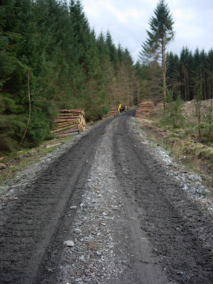 The other side of the logging activities, looking back up the hill. Very muddy in the middle section, rather precarious on the steep downhill bit. Looking forward to that section on the return journey.
 Almost there now. That's the first look at Clatteringshaws Dam.
 And there it is up close.
Built in the mid 1930's, so it's quite an old one.
 Can't get along the top of it though, which is a shame. I'll be in trouble again, taking all these pictures.
 Peering through the railings and looking along the top of the dam.
 So in the gathering gloom, it's time to head back the same way.
See, official Route 7 signs.
 That hill looks far more intimidating when you're tired. Didn't look that steep on the way down.
 It is that steep. For a mile. The muddy bit up beyond these logs was fun. Very low gear, just trying not to stop, because you wouldn't get going again. At least the logging crew had stopped and gone home by this time. You don't want an audience.
 Our intrepid explorer discovers the mythical source of the Black Horse's Best Scotch.
 Lots of pedalling later and the forest gives way to the Big Water Of Fleet Viaduct again.
 And yes, the water really is that colour. It's the peat that does it.
 Luckily, don't have to pedal up there.
 So, back the same way down the valley to Gatehouse and the pub, before heading off to collapse in a big heap.
Time for one last artistic shot of dusk across the Fleet Bay.
Next time, it'll be back on more familiar terrain, and perhaps someone else might manage to do some cycling as well.