skip to main |
skip to sidebar
(Approximately 40 miles)
Dunk and Ian out on the bikes today. Jim and Chris had better plans.Blowing a gale from the west, so we decided to head towards the Derwent Walk as that was likely to be a bit more sheltered.So, it was down through Gateshead and onto the cycle path that runs along the Quayside.

Rain!Ian decided to put on his waterproofs at this time, which was a good idea, as his cycle top was a bit small. Too much bare skin. Not what you want to see. The Wild Man Of Dunston lurches out of the undergrowth.This was behind the Rocket and following an old Garden Festival path, but the route was blocked by a security gate, probably because the staithes had burnt down on the other side.So, it was down an embankment to get back on track.
Ian fell off at this point he says. Missed that. Curses. Rattling along the Derwent Walk.National Cycle Route 14 you know. All leafy and green at this time of year.
 Gravity in action (Downhill)Look at him go.
 Gravity in action (Uphill)Look at him not go.Actually, something snapped in the back axle at this point, so he had to take it easy after this.Was making some very odd noises... and so was the bike (Ba-doom-tish)Anyway, we soon made Consett.
 Tea! Toasty!A sign at Lydgetts Junction guided us to the newly opened Hownsgill Tea-Room.They serve anyone, as you can see.
 Banoffee Gateaux with extra squirty cream.Lovely.
 Dunk taking a mucky picture.In reality, texting Chris to inform him of the rather windy conditions on route. Glad we weren't heading up onto the moors to Parkhead Station like he was later on.
 Ian requires a haircut. Here he is leaving the new tea-room.Tea, bottled water, 2 toasties, and 1 large bit of cake came to £6.95 which was very good.
Recommended. Refueled, and with the strong wind behind us, Birtley was reached in no time.Look you can see the Angel in the distance.
 And there's Dunk cycling around the base of it.A professional took this. You can tell. He's available to do weddings and portraits.A good ride, that.
Approximately 38 miles
A slightly older ride this one. Only just got hold of the photos, so cast your minds back to the beginning of April and just pretend. It's the day before the Corbridge Tea Room Run
thursday cycling instead of fri cos I av to work just me an dunk available bewtiful day so we decided it was the moors for us park in stanley ana nice ride up to parkhead station
(Just Dunk and Mr McDonald today, as it's a Thursday and only the two layabouts weren't working. Some people had to do Thursday as they had a club night to prepare the next day. The dirty old man. Anyway, it was a rather nice day, so we decided to head up to Parkhead Station on the Waskerley Way.
This is the translation of Mr McDonald's rather unique blogging style) dunk ona mission head down straight past the jolly drovers(No stopping for a pint this early in the afternoon)
 liggits junction site of the old steelworks an dunk bracein himsel for a quick slug of hot steel(A rather dodgy attempt at a perspective joke.
It's not easy coming up with good photo ideas you know) dunk demonstratein how to tame the birds at parkhead(Not a real bird, but a wooden one that sits on the fencepost)
tea pepsi an carrot cake at parkhead station dynamic angle actionshot of me bein mother(In the tearoom at Parkhead Station, and Ian masters the art of pouring a cup of tea. Normally he needs a grown-up to help) propper strong tea no skimpin here double teabags(Ian has to provide a sample for the doping authorities)
 dunk lookin expectant hidein behind a giant pepsi bottle then the carrot cake arrives(After some rather lovely toasties, it was time to order carrot cake again. Lovely carrot cake.
While waiting we amused ourselves by taking a picture of the 3D Barcode on the Pepsi bottle.
Actually working out how to claim the prize proved a bit tricky though) what a happy smile
(Carrot cake has arrived. Happy Happy Joy Joy)
 aaaaaaaaaaa tried to freewheel downhill in a train but it wooden go ha ha(Thought we'd take a picture of a train for Jim.
Actually, I think Mr McDonald has found his natural mode of transport) preparein for the off what a brama of a day(After stocking up on fuel, it was time to head back.
The view from the top of the moors was something. You could see for miles.)
dunk was art director fo this shot of sign pointin the way home but sed he wood let me fiddle so a took the oppratuneity wif both hands ina manner of speakin
(See, a bike. On the Waskerley Way.
It's a old railway line you know. And downhill for miles. Sadly, there was a headwind, so not as fast as usual on the way down) me nearly back to car one sweaty bloggers mate(One for the ladies out there)ps. after hour long an ard trip dunkin had a little stiffness (thats wot he calls it) but says it was expertly delt with by a very willing young lady. May of bin the first known application of nut rub xxx(No idea. Probably been drinking)
33 miles approximately (plus another 7 to get to the pub and back) So, once again the Masonic Arms in Gatehouse of Fleet was the starting point, with Duncan still being the only one who can remember how to get on a bike.
Managed to take a picture of the pub this time. Go me.
Set out following National Route 7 again, but this time instead of turning off to Anwoth, it was straight on and up towards the old railway line.
 See, route 7.
Uphill for nearly 7 miles along a very quiet road.
 This is Rusko Tower, built in the 16th Century, and now someone's house.
 Someone clearly doesn't mind the mud, do they?
 Still climbing, but up to 340ft now.
 One of the funky mileposts you see every so often when out on a bike. The Royal Bank Of Scotland spent a few quid sticking these up all over the country.
Before they went bankrupt of course.
 Well, almost at the old station now. That's Cairnsmore in the distance.
 Up to 510ft now, and it's the old trackbed of the Dumfries to Stranraer line, "The Portpatrick Railway". It's a fairly good surface here, but it's hard work cycling along it, as the impression of the sleepers is still evident. You need rear suspension and a fat arse to be able to get any speed up in comfort.
 Looking the other way, this is the actual station building, although now it's someone's house, so you can't go along there.

 A couple of pictures of Gatehouse Station culled from the internet again. Looking west towards Creetown, the buildings are still recognizable in the photo from the 1960's
.
 So, lacking the suspension, it's back off the railway line and onto the adjacent road, which makes up the official "offroad" route 7, onto the Cairnsmore of Fleet nature reserve. That's the Big Water Of Fleet viaduct you can see in the distance. 20 arches.
 The Clints Of Dromore rising up. The railway line runs just the other side of that little green hill, and in places goes through very narrow cuttings. This way is a bit longer, but mainly downhill on some nice tarmac. Apart from avoiding the sheep, a nice respite after the climb up from the sea.
 Viaduct!
Quite impressive stuff.
 All the brickwork was added to strengthen the viaduct during the war, to carry the convoy cargo that came into Stranraer on the west coast.
 And they held it all together with bits of old rail. It's seen better days really.
 Risking life and limb to get these shots.
 It doesn't lean as much as this picture shows, honest.
 Up the embankment, and onto the old trackbed, and this is the scene at the end of the viaduct.
The security fence has been partially removed, after having been closed off for a decade or so.
Supposedly, Sustrans own it now, so it's possible they're planning to make it safer and open the route up in future.
 Artistic shot. It's really high up actually. No safety net or anything.
 This is possibly for keeping sand in. It just sort of hangs over the edge of the embankment. Quite odd.
 You can still see the impression of the old railway line and where the ballast was banked up at the sides. 43 years since the track went.
 It's a very big embankment leading up to the viaduct.
 Look how clean that bike is. Makes a nice change.
This is looking west, back along the line towards the old station
 So, viaduct behind, it's off again along route 7 and onto the proper off-road bit.
A dark and dingy forest.
 But just around the corner, here's a scene of devastation. Looks like a bomb's gone off.
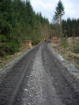
 This is where all the trees have gone. A lot of logs, stacked up along the roadside for the next mile or so.
 The logging machines make a bit of a mess of the road, so when they're done, they fill in the muddy bits and the holes with this really coarse crushed stone. Not nice for cycling on at all. There was a bit too much of this.
 Action shot! We've had cows, we've had sheep, and now we have goats.
Wild goats. They weren't hanging around to have their picture taken though.
Where was Doctor Doolittle?
 Cairnsmore. Don't often get to see it from this angle. The sun came out at this point, and with no cover, it was baking hot.
 Wherever the loggers have been, there were these solitary trees trunks left standing every few hundred yards. Maybe it's for the birds.
 A bit further along the trail, looking back at Loch Grannoch.
Past the highest point now, which is about 900ft, so until we get to Clatteringshaws Loch, most of it is downhill.
 First view of Clatteringshaws Loch in the distance.
The loggers are working in this area, and the track is starting to get churned up.
 The other side of the logging activities, looking back up the hill. Very muddy in the middle section, rather precarious on the steep downhill bit. Looking forward to that section on the return journey.
 Almost there now. That's the first look at Clatteringshaws Dam.
 And there it is up close.
Built in the mid 1930's, so it's quite an old one.
 Can't get along the top of it though, which is a shame. I'll be in trouble again, taking all these pictures.
 Peering through the railings and looking along the top of the dam.
 So in the gathering gloom, it's time to head back the same way.
See, official Route 7 signs.
 That hill looks far more intimidating when you're tired. Didn't look that steep on the way down.
 It is that steep. For a mile. The muddy bit up beyond these logs was fun. Very low gear, just trying not to stop, because you wouldn't get going again. At least the logging crew had stopped and gone home by this time. You don't want an audience.
 Our intrepid explorer discovers the mythical source of the Black Horse's Best Scotch.
 Lots of pedalling later and the forest gives way to the Big Water Of Fleet Viaduct again.
 And yes, the water really is that colour. It's the peat that does it.
 Luckily, don't have to pedal up there.
 So, back the same way down the valley to Gatehouse and the pub, before heading off to collapse in a big heap.
Time for one last artistic shot of dusk across the Fleet Bay.
Next time, it'll be back on more familiar terrain, and perhaps someone else might manage to do some cycling as well.


