skip to main |
skip to sidebar
33 miles approximately (plus another 7 to get to the pub and back) So, once again the Masonic Arms in Gatehouse of Fleet was the starting point, with Duncan still being the only one who can remember how to get on a bike.
Managed to take a picture of the pub this time. Go me.
Set out following National Route 7 again, but this time instead of turning off to Anwoth, it was straight on and up towards the old railway line.
 See, route 7.
Uphill for nearly 7 miles along a very quiet road.
 This is Rusko Tower, built in the 16th Century, and now someone's house.
 Someone clearly doesn't mind the mud, do they?
 Still climbing, but up to 340ft now.
 One of the funky mileposts you see every so often when out on a bike. The Royal Bank Of Scotland spent a few quid sticking these up all over the country.
Before they went bankrupt of course.
 Well, almost at the old station now. That's Cairnsmore in the distance.
 Up to 510ft now, and it's the old trackbed of the Dumfries to Stranraer line, "The Portpatrick Railway". It's a fairly good surface here, but it's hard work cycling along it, as the impression of the sleepers is still evident. You need rear suspension and a fat arse to be able to get any speed up in comfort.
 Looking the other way, this is the actual station building, although now it's someone's house, so you can't go along there.

 A couple of pictures of Gatehouse Station culled from the internet again. Looking west towards Creetown, the buildings are still recognizable in the photo from the 1960's
.
 So, lacking the suspension, it's back off the railway line and onto the adjacent road, which makes up the official "offroad" route 7, onto the Cairnsmore of Fleet nature reserve. That's the Big Water Of Fleet viaduct you can see in the distance. 20 arches.
 The Clints Of Dromore rising up. The railway line runs just the other side of that little green hill, and in places goes through very narrow cuttings. This way is a bit longer, but mainly downhill on some nice tarmac. Apart from avoiding the sheep, a nice respite after the climb up from the sea.
 Viaduct!
Quite impressive stuff.
 All the brickwork was added to strengthen the viaduct during the war, to carry the convoy cargo that came into Stranraer on the west coast.
 And they held it all together with bits of old rail. It's seen better days really.
 Risking life and limb to get these shots.
 It doesn't lean as much as this picture shows, honest.
 Up the embankment, and onto the old trackbed, and this is the scene at the end of the viaduct.
The security fence has been partially removed, after having been closed off for a decade or so.
Supposedly, Sustrans own it now, so it's possible they're planning to make it safer and open the route up in future.
 Artistic shot. It's really high up actually. No safety net or anything.
 This is possibly for keeping sand in. It just sort of hangs over the edge of the embankment. Quite odd.
 You can still see the impression of the old railway line and where the ballast was banked up at the sides. 43 years since the track went.
 It's a very big embankment leading up to the viaduct.
 Look how clean that bike is. Makes a nice change.
This is looking west, back along the line towards the old station
 So, viaduct behind, it's off again along route 7 and onto the proper off-road bit.
A dark and dingy forest.
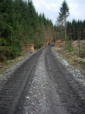
 But just around the corner, here's a scene of devastation. Looks like a bomb's gone off.
 This is where all the trees have gone. A lot of logs, stacked up along the roadside for the next mile or so.
 The logging machines make a bit of a mess of the road, so when they're done, they fill in the muddy bits and the holes with this really coarse crushed stone. Not nice for cycling on at all. There was a bit too much of this.
 Action shot! We've had cows, we've had sheep, and now we have goats.
Wild goats. They weren't hanging around to have their picture taken though.
Where was Doctor Doolittle?
 Cairnsmore. Don't often get to see it from this angle. The sun came out at this point, and with no cover, it was baking hot.
 Wherever the loggers have been, there were these solitary trees trunks left standing every few hundred yards. Maybe it's for the birds.
 A bit further along the trail, looking back at Loch Grannoch.
Past the highest point now, which is about 900ft, so until we get to Clatteringshaws Loch, most of it is downhill.
 First view of Clatteringshaws Loch in the distance.
The loggers are working in this area, and the track is starting to get churned up.
 The other side of the logging activities, looking back up the hill. Very muddy in the middle section, rather precarious on the steep downhill bit. Looking forward to that section on the return journey.
 Almost there now. That's the first look at Clatteringshaws Dam.
 And there it is up close.
Built in the mid 1930's, so it's quite an old one.
 Can't get along the top of it though, which is a shame. I'll be in trouble again, taking all these pictures.
 Peering through the railings and looking along the top of the dam.
 So in the gathering gloom, it's time to head back the same way.
See, official Route 7 signs.
 That hill looks far more intimidating when you're tired. Didn't look that steep on the way down.
 It is that steep. For a mile. The muddy bit up beyond these logs was fun. Very low gear, just trying not to stop, because you wouldn't get going again. At least the logging crew had stopped and gone home by this time. You don't want an audience.
 Our intrepid explorer discovers the mythical source of the Black Horse's Best Scotch.
 Lots of pedalling later and the forest gives way to the Big Water Of Fleet Viaduct again.
 And yes, the water really is that colour. It's the peat that does it.
 Luckily, don't have to pedal up there.
 So, back the same way down the valley to Gatehouse and the pub, before heading off to collapse in a big heap.
Time for one last artistic shot of dusk across the Fleet Bay.
Next time, it'll be back on more familiar terrain, and perhaps someone else might manage to do some cycling as well.
Approximately 25 miles (plus another 7 miles to get to the pub and back)Well, due to a variety of factors, attendance has been a bit lax of late, so it's down to Duncan to actually get on his bike. The Dumfries and Galloway area of South West Scotland was the venue, where the workshy fop was enjoying a break near Gatehouse Of Fleet.
After a misty start to the day, the late afternoon saw an improvement in the weather, and for the purposes of this blog, the starting point was a fine establishment in the town, The Masonic Arms pub, which gives the Black Horse a run for it's money in the Guinness stakes.
 Here's a shot of the pub culled from the net, as I forgot to take one at the time. This is actually on National Cycle Route 7, so that was followed for a mile or so, out of the town, before turning off towards the ancient dwelling of Anwoth and onto the Old Military road dating from 1763 apparently.
The OS maps of the area have this down as an "other road", but clearly a road. LIES!
Hoisting the bike over a gate, it was up the steep wooded hill, and you can well believe the road was built in 1763. It hadn't been raining for a good few days, so perhaps the small stream running down the "road" should have been a sign of things to come.
 That's a bloody steep hill, and not the best surface for cycling on. Just around that corner most of the road had been washed away, and it was inches deep with thick black mud and cow shite. I wasn't stopping to take photos, and inched forward through it in a very low gear.
I can see why the road had a gate across it. They don't show that on the map.
 This is looking back towards the woodland and that steep hill from Anwoth. That was about a foot deep in the middle, the bike went along the side through the boggy ground. Not good, but surely the worst was over.
 Here, our rugged hero surveys the road ahead in this very artsy self-timer shot. Quite impressive that the wind didn't blow the camera off it's precarious perch on a fence post.
Notice the rather steep hills along the side of the track. Perhaps a bit of a rain catchment area. A tractor had obviously been along here at some point, and sunk in just a touch in places. Hard to turn back, as that steep hill behind us was too treacherous to be safe and you probably wouldn't get found for days.
 Oh joy. More mud. And tractor tyre ruts. It was quite overcast and gloomy, hence the slightly blurred nature of a few of these pictures. And about ten to six as well.
 But the views are quite good.
 At last, a dry bit. Optimism was rising at this point that the worst was over. Red coats (the soldiers, not the Butlins mafia) had probably trodden those very stones quelling some uprising.
 Mutant gorse bushes from all the Chernobyl fallout no doubt.
 And then you go around a corner, and it's a flooded mudbath again. Much swearing. Way too deep and claggy to cycle through, a path was found through the gorse bushes by the wall. Shoes were somewhat soggy at this point.
 Action Shot! The road surface had improved by now though. Well, at least it was dry. Like cycling over a ploughed field.
 At the bottom of a really steep and rutted bit, to go over the crest of Ardwall Hill. Like 45° steep. Bike was pushed up.
 Top of the hill looking back down. Only about a mile along the Old Military Road. Felt like ten.
 Then at the top of the hill, the first view of our target. Cambret Hill, and the transmitter masts sitting on the top. They're at over 1100ft, the bike was currently at 470ft
.
 A welcome downhill bit, leafy country lanes, that sort of thing. There was more gate climbing to be done just here. I'm not a fan of gates.This nifty little panorama was made with the free Autostitch software. Dead simple. Worth a go.
 Kings Laggan farm nestling under the slopes of Kenlum Hill, which is rather pointy.
 Civilisation!
 So this is where I'd just come from. Maybe they could have had a sign at the other end too. That would have been nice.
I'm not sure it's even suitable for tractors.
And with the hard bit over, it was sensible roads for the duration of the ride. Onwards towards Glen, or at least that was the plan, but 500 yards further on......
 As you can see, the stampede meant the road was blocked. More followed around the corner, so with the phrase "bloody farmers" echoing around the valley, it was back to the crossroads at Kings Laggan.
Now I could either abort the ride and go back along the Old Military Road, but that wasn't a sensible option, so it was all the way back down the valley, almost to Skyreburn on the coast and up the other side again. Big detour.
 Still, at least it was going to be downhill for a while, and it's a nice spot of countryside to cycle through and it was only 6.30pm. Of course, probably only about a quarter of the way around unless I went back via the A75. Which is not a good idea if you want to live.
 So, after dropping down the valley to the dizzy altitude of 150ft and within spitting distance of the sea, this is the view from the road on the other side, looking back at the farmhouse where the cows were blocking the way. If it looks like it's miles away, it's because it was. Three to be exact.
 So, once past Glen, which is no more than a T-Junction, the road is known as "The Corse Of Slakes", another ancient route. At least this one has seen some tarmac in the last decade or so.
Starting to climb quite steeply up onto the moors too, but still only about 500ft up.
 Looking back towards Gatehouse, which is over those hills in the middle. You can just make out the path of the Old Military Road going over them too.
 Looking back a bit further up the climb, the vegetation is thinning out now, and once over the cattle grid, it's onto the moors proper. Sheep are lurking. You never see a sheep grid though.
 And there's the transmitter on Cambret Hill. It's getting close, but it's a steep climb into a fierce headwind whipping over the tops of the hills. Not much traffic up here, so you have to hope there's no mechanical failures, or you might not be found for days. No mobile signal of course. What are those masts for then?
 Up a small access road to the transmitter station, and we reach 1000ft above sea level at this gate, as close as you could get. Probably on a list of terrorist suspects already for these pictures.
The Irish Sea is just a couple of miles over the hill to the left, and the wind gale is bitter.
 Looking north down the little road to the transmitter, back across the moors. The cloud-shrouded mountain in the distance is Cairnsmore, the highest around. Another swanky panorama.
It was about 7.40pm now and starting to get a bit gloomy. That slow first couple of miles and the detour had messed up the timing, but luckily I'm used to cycling with Jim so I'd brought my lights just in case.
Time for a blast down the other side of Cambret Hill, heading west towards Creetown, and then loop back east onto the road following the course of the old Portpatrick Railway.
 The low light levels made for few photos that weren't a blurry mess, but this one shows one of the little stone bridges crossing one of the burns. It's a gradual climb from the coast, back up to the station at 500ft
.
Done a lot of climbing. Just for Jim, here's a little sheep tunnel crossing under the old trackbed.
All the sheep had gone to bed by this point.
(Not with Jim)
 Just past Gatehouse of Fleet station at the highest point of this stretch, and in the distance you can just make out the Big Water Of Fleet viaduct. That's another bike ride that one.
Almost dark now. Those lights are great.
And then it was downhill all most of the way back to Gatehouse. It's still over 6 miles back to the town, into a headwind off the sea. You shouldn't have to pedal downhill. It's not right.
 Rather dark by the end of the ride.
Very tired too. Done a lot of hills. Climbing over 1800ft in total. Ow. A good ride though.
 And just to finish, a shot of my shoe the next day. Won't be riding that Old Military Road again, unless we have a two month drought first.


